Contact Us

If you still have questions or prefer to get help directly from an agent, please submit a request.
We’ll get back to you as soon as possible.

Please fill out the contact form below and we will reply as soon as possible.

  • Contact Us
  • Home
  • Working with LiDAR data

Importing LiDAR data

Written by Cody Yakimoff

Updated at September 12th, 2023

Contact Us

If you still have questions or prefer to get help directly from an agent, please submit a request.
We’ll get back to you as soon as possible.

Please fill out the contact form below and we will reply as soon as possible.

  • Getting started
    Fundamentals Tutorial: Your first design
  • Network design & analysis
    Project setup Overhead Underground Measuring Clearances Working with Terrain
  • Working with LiDAR data
    Automatic LiDAR Classification Modelling with LiDAR
  • Reports and visualizations
    Vegetation Management Formula language reference
  • Collaboration
    Segmenting, importing, and comparing designs
+ More
  • Getting started
      • A video overview of Neara
    • Fundamentals
        • Recommended devices & supported browsers
        • Creating an account & logging in
        • Setting up your organization account & users
        • First-time setup
        • The Home screen & your first Project
        • Using the Project screen & workspaces
        • Project design settings
        • Moving and selecting objects
        • Positioning and orienting the camera in 2D and 3D views
        • Review & export Project settings as a template
        • Collaborating on designs with other users
        • Connecting external cloud data sources
        • Create a cross section of your model in the Profile view
        • Importing a model/template file
        • Set a project's units of measurement to Metric or US
        • Improving display performance
    • Tutorial: Your first design
        • 1 - Create a new, blank project
        • 2 - Georeferenced map overlay and terrain building
        • 3 - Creating poles, conductors, components and assemblies
        • 4 - Modelling the existing network
        • 5 - Modelling changes to a network
        • 6 - Checking Clearances
        • 7 - Exporting Reports
  • Network design & analysis
      • About Options and multi-project designs
    • Project setup
        • Working with the coordinate system
        • Setting up and using Environments
        • Adding a map overlay to your design
        • Create a cross section of your model in the Profile view
        • Viewing & using datasets in your network model
        • View options: asset color coding, displayed visuals, and point cloud display
        • Video: Scoping in Neara Designer
        • Video: Rapid project scoping for overhead powerline design
        • Video: View and export profiles of overhead line models
        • M(z,cat) Gust Wind Speed Multiplier
        • Span Reduction Factor SRF and Tension Section Reduction Factor TSRF
        • Importing a model/template file
        • Set a project's units of measurement to Metric or US
        • Improving display performance
        • Issues importing DXF files
      • Using Libraries
          • Using and updating libraries
          • The Constructions (Assemblies) library
          • The Constructions and Components Library
          • Example Constructions and Components
          • No cable constructions
          • Creep Modelling
          • Video: Editing Pole Top Constructions
          • Video: Editing Pole Top Construction components
          • Pole Library: Derive Modulus of Rupture From Tipload
          • How do I create a new construction?
          • How do I model a T-junction construction?
          • How do I change from one pole top construction to another?
          • How do I create a new component?
      • Using Environments
          • Setting up and using Environments
          • Video: Conductor Environment labelling
          • Overview Limit State Table
    • Overhead
        • About Options and multi-project designs
      • Poles
          • Placing poles
          • Adding a stay/guy wire to a pole
          • Using precision relative placement to place poles relative to other objects
          • Extracting & fitting poles to LiDAR and working with imagery tiles
          • Using the Snap tool to fine tune the fit of poles & conductors to LiDAR data
          • Analysing the impact of single & multiple stays on a pole
          • Viewing detailed tip load results in the Tip Load panel
          • Classify spans and poles to be existing, new, replaced, re-tensioned, or removed
          • Video: Using the precision placement tool
          • Video: Editing Pole Top Constructions
          • Video: Editing Pole Top Construction components
          • Overview Limit State Table
          • Resultant Forces Graph
          • Detailed Forces table
          • Creating mid-span Poles
          • Setting a manual or calculated custom Pole Strength
          • Specifying Pole Lean
      • Conductors
          • Using the Conductor tool to place & configure conductor spans
          • Viewing & modifying conductor span properties
          • Setting conductor properties
          • Splitting conductors
          • Joining conductors
          • Creating and attaching Mid-cable Objects to spans
          • Using the Snap tool to fine tune the fit of poles & conductors to LiDAR data
          • Measuring Blowout distance
          • Measuring conductor clearances
          • Measuring ground clearance
          • Individual cable tensions on a conductor span
          • Creep Modelling
          • Classify spans and poles to be existing, new, replaced, re-tensioned, or removed
          • Video: Using the NESC Ground Clearance tool
          • Video: Creating Multiple Conductor Groups
          • Video: View and export profiles of overhead line models
          • Set up derating strength factors on conductors, poles, and components
          • Creating mid-span Poles
          • How do I specify a precise span length?
          • How do I extend an existing conductor?
          • How do I insert a pole into an existing conductor span?
          • How do I find the blowout of a span?
          • Defining Bimetallic Conductors
          • Analysing Bimetallic Cables
      • Stays / Guys
          • Adding a stay/guy wire to a pole
          • Analysing the impact of single & multiple stays on a pole
          • Overview Limit State Table
          • Resultant Forces Graph
          • Detailed Forces table
          • The Stay editor
          • How to model a Side-Walk Stay?
      • Crossarms
          • Overview of crossarm parameters
          • Crossarm parameter: Second Moment of Area
          • Crossarm parameter: Torsion Constant
          • Crossarm parameter: Section Modulus
          • Crossarm parameter: Material
          • Crossarm parameters: Length, width, depth
          • Crossarm parameter: Mass
          • Crossarm parameter: Maximum Bending Moment
          • Crossarm parameter: Max Bending Moment vs Horizontal/Vertical
          • Crossarm parameter: Material Strength
          • How do I create a double cross-arm?
      • Obstructions and structures
          • Modelling obstructions such as buildings and fences
      • Structural analysis
        • Wind analysis
            • Wind and Weight Spans
            • Wind Speed
            • Wind Speed - Australia / New Zeland
            • M(z,cat) Gust Wind Speed Multiplier
            • Span Reduction Factor SRF and Tension Section Reduction Factor TSRF
        • Finite Element Analysis (FEA)
            • Analysing the impact of single & multiple stays on a pole
            • Design Setting - Removed Status Stops Loads From Being Applied
            • Set up Simulations for use with FEA
            • Set up derating strength factors on conductors, poles, and components
            • FEA: Unstressed Lengths
            • FEA: Deflection and Rotation Angle
            • FEA: Load Source
            • FEA: Load Factors
        • Static Analysis
            • Analysing the impact of single & multiple stays on a pole
            • Viewing detailed tip load results in the Tip Load panel
            • Design Setting - Removed Status Stops Loads From Being Applied
            • Set up derating strength factors on conductors, poles, and components
            • Overview Limit State Table
            • Resultant Forces Graph
            • Detailed Forces table
            • Setting a manual or calculated custom Pole Strength
        • Calculations
            • Example models from AS7000 HB 331-2012
            • Sag Measurement
            • General Conductor Properties and calculations
            • Blowout Calculation
            • Tip Load Calculations
            • Stay Calculation
            • Sag Tension Calculation
            • Pole Plant Calculation
            • Span Clearance Calculations
            • Catenary Definition
            • Torsion Constant
            • Neutral Axis
            • Moments of Area
            • Second Moment of Area
            • Section Modulus
            • Maximum Bending Moment
            • Modulus of Elasticity
            • Stress / Strain
            • Maximum Bending Stress / Material Strength
            • Common Shapes: Second Moment of Area and Torsion Constant
    • Underground
        • 1 - Underground tools
        • 2 - Modelling an existing underground network
        • 3 - Single lot subdivision example
        • 4 - Large lot subdivision example
        • Underground voltage drop reports
        • Underground cable tension reports
    • Measuring Clearances
        • Setting up and using Environments
        • Measuring conductor clearances
        • Measuring ground clearance
        • Measuring Blowout distance
        • Using the NESC Clearance Rules tool
        • Video: Using the NESC Ground Clearance tool
        • How do I measure clearances?
    • Working with Terrain
        • Adding feature points with real-world elevation data from Google Earth Elevation / KML
        • CSV structure and feature codes for Survey import
        • Creating a ground / terrain profile using the Survey tool
        • Video: Importing elevation data
        • Model Terrain Override for Poles
  • Working with LiDAR data
      • Importing LiDAR data
      • Troubleshooting LiDAR import issues
      • Improving display performance
    • Automatic LiDAR Classification
        • Step 1: Import & preview LiDAR data
        • Step 2: Automatically classify LiDAR data
        • Step 3: Exporting classified LiDAR data
    • Modelling with LiDAR
        • Quickstart: Overview of modelling with LiDAR
        • Video: Modelling with LiDAR in Neara
        • View options: asset color coding, displayed visuals, and point cloud display
        • Manage density, view, and sets of LiDAR
        • Extracting & fitting poles to LiDAR and working with imagery tiles
        • Using the Snap tool to fine tune the fit of poles & conductors to LiDAR data
        • Viewing & using datasets in your network model
  • Reports and visualizations
      • An introduction to Neara Reports
      • Preset reports
      • Creating custom reports
      • Managing existing Reports
      • Working with tables in Reports
      • Using formulas in reports
      • Interactive Parameter controls in Reports
      • Export data from a Report
      • Quick exports with built-in Reports
      • Built-in Point Cloud clearance report
    • Vegetation Management
        • Vegetation management: Overview
        • Vegetation management: Identification
        • Vegetation management: Prioritization
        • Vegetation management: Operationalize
        • Vegetation management: Audit
    • Formula language reference
        • Using formulas in reports
        • Logical & Boolean operations
        • Mathematical operations
        • Constants
        • Text operations and formatting
        • Units: types and operations
        • Lists and Collections
        • Engineering operations, calculations, and simulations
        • Geometries and Bodies
        • Creating Volumes and making Point Cloud selections
        • User Interface operations
        • Miscellaneous operations
        • Example formula: Custom clearance height check
  • Collaboration
      • Viewing, adding, and working with comments on designs
    • Segmenting, importing, and comparing designs
        • About Options and multi-project designs
        • Importing a design Option from a related project
        • Comparing design Options
        • Working with Asset Statuses in Neara

Table of Contents

Sample data Import LiDAR data Using Automated LiDAR Classification? LiDAR data text file (.txt) format

Sample data

A text file containing sample LiDAR data is attached to this article. Download it to your device so you can inspect the required format and try out this feature in your project:

Download the sample LiDAR data file

If your browser displays the LiDAR text file in a new tab, rather than downloading it when you click the link above, right-click it and choose the option to Save the linked file (or similar option) to your device.


Import LiDAR data

Using Automated LiDAR Classification?

If you're using Neara's new Automated LiDAR Classification feature, it features a new Importer with more flexible options for importing LiDAR data


To import LiDAR data stored in .las, .laz or .txt files, use the Import PointCloud Data panel. Click the (+) at the right hand end of the tabs in any section of the workspace and select that option from the popup:


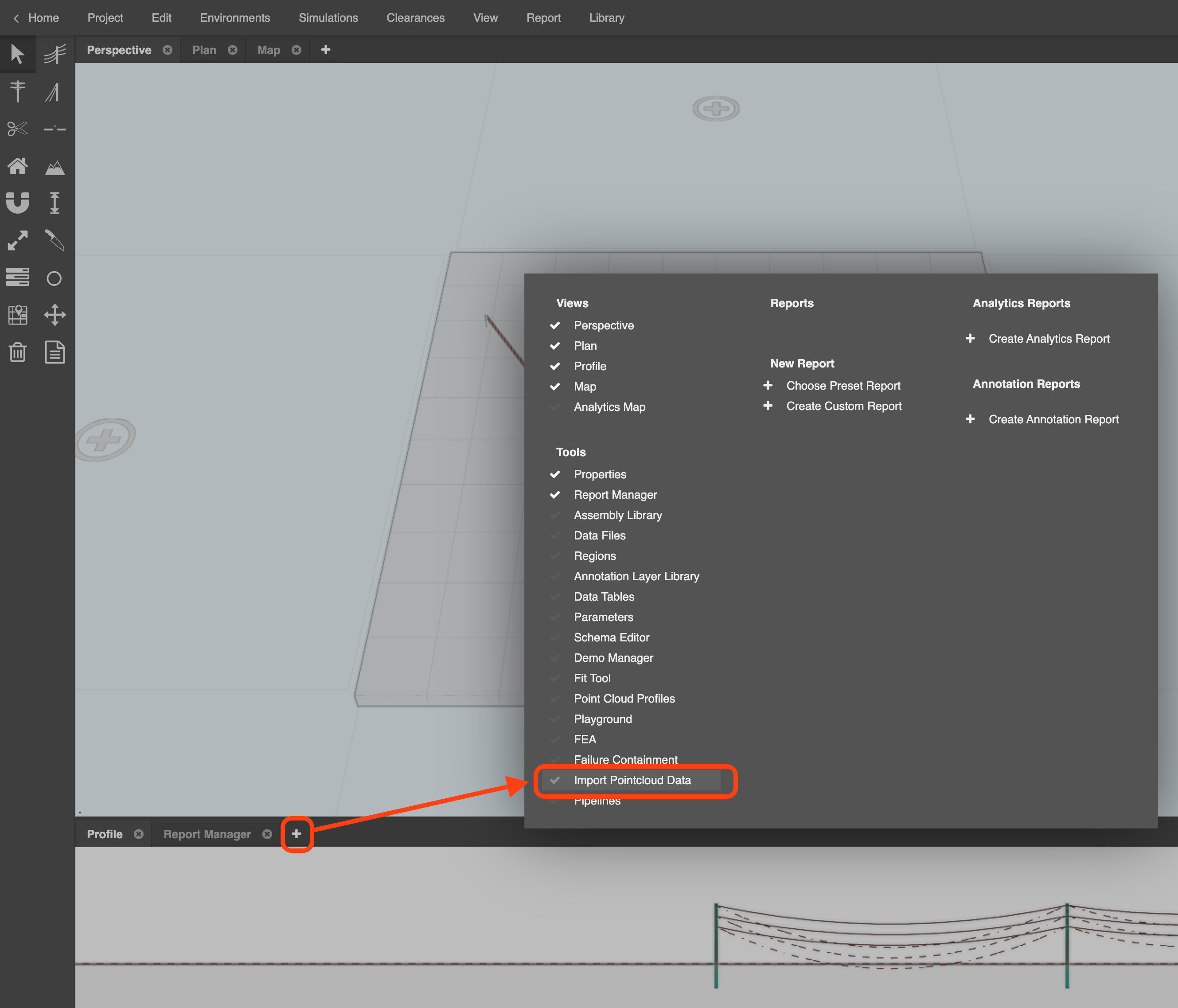
The panel will appear. You may need to resize it to see all the import options:


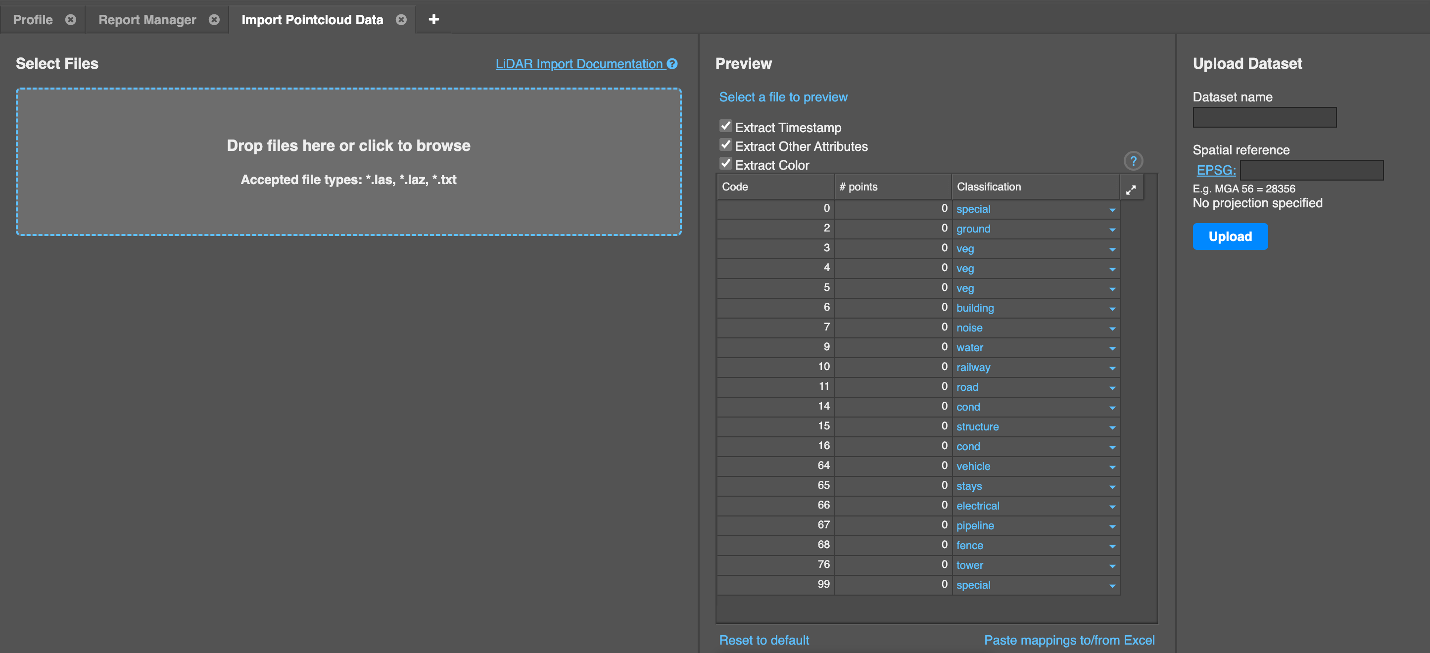
Drop the LiDAR data file (.las, .laz, or .txt file format) into the “drop” box area, or click that box to browse for the file on your device.

Neara will start to process the data in the file, and will provide a preview of the point classification mappings that you can modify if required before completing the upload and import process. 

For convenience you can copy/paste existing mappings to from Excel using that link at the bottom of the panel.

Once your mappings are ready, add the Dataset name in the right hand panel. You should also assign it a correct Spatial Reference by entering a valid EPSG code in that field in the right hand panel, so that it can geo-reference itself with a map overlay. 

Finally, click Upload to store it in the cloud and make it accessible in your project:

Your browser does not support HTML5 video.


LiDAR data text file (.txt) format

If you're importing LiDAR data from a text (.txt) file, Neara requires the data in the file to be in the following format. If the format is incorrect, it will not be imported:

x y z c

Where each of the following elements are separated by a single space, and each point appears on a new line. There is no header row:

  • x - the x coordinate
  • y - the y coordinate
  • z - the z coordinate (height)
  • c - the classification of the LiDAR points
Code Classification
0 Special
2 Ground
3, 4, 5 Veg
6  Building
7  Special
9 Water
10 Railway
11 Road
14 Conductor
15  Structure
16 Conductor 
99 Special


A text file containing sample LiDAR data is attached to this article. Download it to your device so you can inspect the required format and try out this feature in your project:

https://static.helpjuice.com/helpjuice_production/uploads/upload/image/12960/direct/1672718569698-example%2Blidar.txt


importing lidar

Was this article helpful?

Yes
No
Give feedback about this article

Related Articles

CSV structure and feature codes for Survey import

Using the Snap tool to fine tune the fit of poles & conductors to LiDAR data

Extracting & fitting poles to LiDAR and working with imagery tiles

View options: asset color coding, displayed visuals, and point cloud display

  • About

    • Learn More
    • How it Works
    • Why Neara
    • About Neara
    • Resources
    • Careers
  • For Geospatial

    • LiDAR Classification & Insights
    • Automatic LiDAR Classification
    • Vectorization & Insights
  • For Utilities

    • Network Digitization
    • Network Design & Construction
    • LiDAR & GIS Reconciliation
    • Network Health & Reliability
    • Asset Health Management
    • Vegetation Management
    • Dynamic Line Rating
    • Clearance Analysis
    • Weather Resilience & Grid Hardening
    • Wildfire Management
    • Hurricane & Storm Management
    • Flood Management
    • Snow & Ice Management
    • Renewable Energy & Decarbonization
    • Transmission Design & Optimization
    • Renewable Enegy Integration
    • Interconnect Request Management
Neara

info@neara.com

©2023 LineSoft Pty Ltd. All Rights Reserved. ABN: 84 6066 33443.
The Neara® word mark and logos are registered trademarks owned by LineSoft Pty Ltd.

Privacy Policy  |  Terms of Service

Expand